| East Africa Home |
| Greetings Home |
Crtd 05-01-01 Lastedit 15-10-27
Greetings
from Lake Victoria
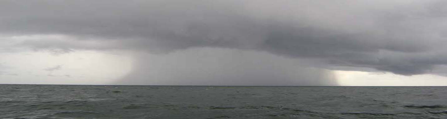
A storm on Lake Victoria (more Pictures of Storms - and how we cope with them at our home mooring); Lake Victoria Maps
Lake Victoria is the
biggest rain vessel in the world. It
has the size of Ireland. All
water falling within the brown envelope of the map below is in the Nile basin, essentially on its
way to Egypt, the Mediterranean Sea, Gibraltar a journey of almost 6000 km, that
is 1/7th of the circumference of the earth. But
before running downwards, first it fills all depressions in the landscape.
They become pools and lakes. Victoria Lake is such a
rain water store, 1130 meters
above sea level! When the rain
fills the pool, it will eventually flow over somewhere. That turned out to be at
Jinja, called by Speke the "source of the Nile".
A romantic, but not too accurate name, because strictly, the rain falling
within the area of the
water shed forms that source. Jinja is just the overflow. There are no other
overflows, nor places the would become and overflow if the Lake would rise
several meters. Meanwhile in billions of years, the Lake has carved a deep
trench for itself at Jinja, so it does not need any more overflows. Despite the
construction of an electricity dam at Jinja, the Lake level went around one
meter down in the past seven years.
It is not inappropriate to see the half of Uganda that is closest to the Lake as
an archipelago of connected islands in a surrounding of a swamps generated by the
rainfall within the Lake Victoria-Nile water sheds. At a slightly lower level
two other big lakes, Kyoga and Albert, are depressions filled by this water, through the
Nile and tributaries.
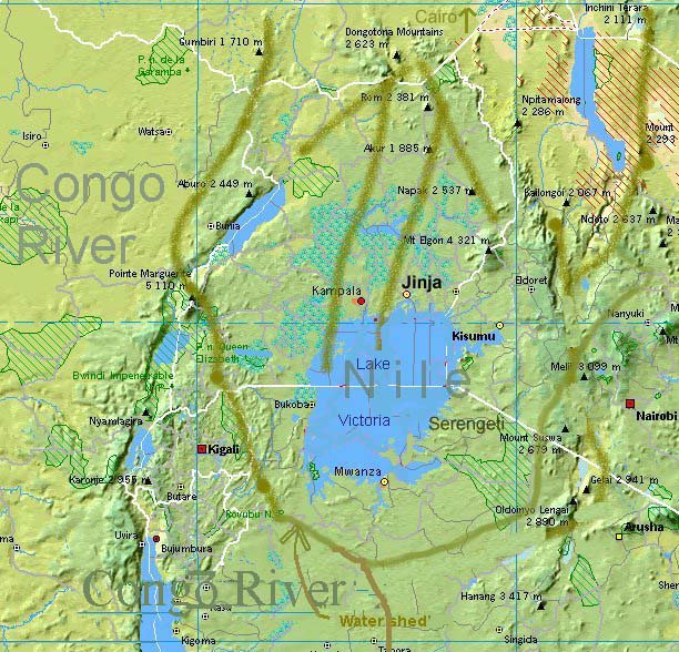
Photo: from above. Water within the confines of the
water shed ("catchment's area") flows to the Mediterranean Sea (3500km straight line). East of the
Serengeti water is flowing to the Indian Ocean (800 km straight). On the West
side of Rwanda and Burundi it is going down to Congo River, ending in the
Atlantic Ocean (2500 straight). The arrow head of "Water Shed", where Nile and
Congo water
part, is a four hours walk from the nearest mooring place at the lake shore, In Biharamulo, a natural reserve and game park without tourists.
Go to:
More Maps.
The Lake shore is 1400km if you draw a line never more than 20 km off the coast. It has no international waters and is divided between Tanzania (South, 800km), Uganda (North 320km) and Kenya (a small section Northeast 280km). There are more pirates than customs officers active on the Lake (though it should also be said that the principles of operation of these two groups do not differ that much).
The coasts, shores and islands are popular for human settlement. Do not expect any of the thousands of islands to be uninhabited. People settle on islands where not even trees do. Where there are some, they are cut for firewood. Demand for fish drives population up. Yet every now and then you find some unprotected wildlife. Despite primitive fishing methods, there is a rapid decline of fish populations [details]
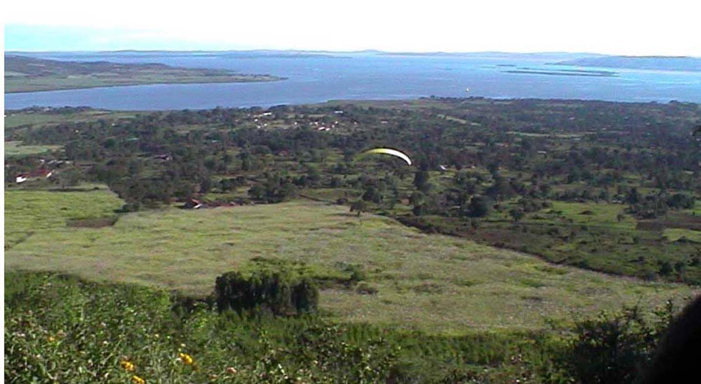
Photo: from the North, Mwiri Hill, near Jinja, with author's parasail.
 Of
course (!) Lake Victoria was discovered by an Englishman in the 19th
century, and only after an extensive and hot academic debate recognized on that island as the source of the Nile , but see left an Arab map of which copies
were already in Spain 400 years earlier. But this is not the only popular
misbelief....
Of
course (!) Lake Victoria was discovered by an Englishman in the 19th
century, and only after an extensive and hot academic debate recognized on that island as the source of the Nile , but see left an Arab map of which copies
were already in Spain 400 years earlier. But this is not the only popular
misbelief....
Some more popular misbeliefs about Lake VictoriaThe misbelief The fact The lake level goes down due to climate change The lake level goes up The level goes down due to electricity dam water outlet Electricity dam water outlet is less the 1% of fluctuations in rainfall and evaporation in the catchment's area Nile perch ate all cichlids Cichlids abound everywhere People eat fish heads because the fillet goes to rich countries People eat fish head because this is considered to be the most delicate part of the fish Whatever economic progress made in East Africa is caused by western aid pumping money in Whatever economic progress made in East Africa is caused by profit making entrepreneurs, almost exclusively from Indian origin, retrieving money out of the hands of African consumers
We sailed all around the lake in 2007. Logbook: The Big RoundGo to: The Standard Weather System on Lake Victoria, vessels and business
| East Africa Home |
| Greetings Home |