Crtd 07-11-05 Lastedit 15-09-14
A Surprise Island
Flying Kisumu Bay
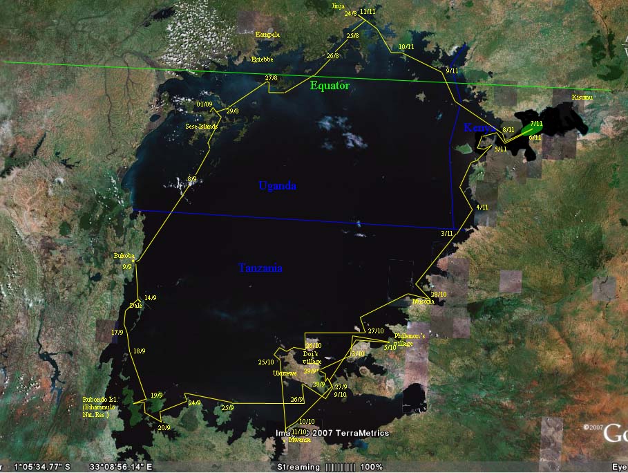
20:30 Heading NW for Kisumu Bay, Kenya, we reach what our time honoured English admiralty map of 1900-1901 calls "Mbita passage", the channel between Rusinga Island (North side ) and the mainland (South side, location: see map point 05/11). Dark. But we see cars where we thought we would go. We moor for better view tomorrow morning.
071106 06:15 In the morning twilight we see that Mbita passage is a channel no more: a dam, electricity wires and traffic,
Photo: "Mbita passage", morning twilight. Channel no more (location: see map point 05/11)
understandably not indicated on
the English admiralty map, but neither on any of our two more recent maps. Finally some progress in Africa and now
we are suffering from it! We head back West to round what now should be called Rusinga
Peninsula.
11:00 We reach Rusinga "Island" West point Northward over
starboard on a W2! 12:00 NE 2, we moor. 14:30 Start of afternoon W 2
freshening to 5-6 on which we make between 11 and 15 km/hrs. At dusk we
enter Kisumu Gulf (called Cavirondo Gulf on the admiralty map). Kisumu 40 km NE. Sailing in in
the dark is no problem since we are far from land everywhere and we see no
fishermen at all. In the dark
at 19:45 crew spots an "island", quite near in front. According to our maps the
next land should be Kisumu at 32 km, and there is one island 45o left
to our course at 10 km. Philemon decides to anchor. I am under deck cooking my
spaghetti and repairing a floodlight, shrug my shoulders, simply waiting for request to lower sail.
I lower. We anchor (point 1 of animation below). I am invited by Philemon to come and look. Our floodlight
torches show a high reed shore of indefinite length left and right, at 20 meters
from the dhow. Day's total 78 km. Due to surprise island scare, captain has to wait before his nerves allow
him to eat his spaghetti. Meanwhile on the W wind, the island moves away from us
direction Kisumu: a huge field of floating reed, papyrus and water hyacinth.
At night Philemon wakes us to witness the return of the plant island on the
late night/morning E. At that moment we should have had the wits to lift the
anchor and float back SW with the W "shore" of the floating island. But we stayed on
anchor, hearing the grazing sound of the plants blown past us towards the SouthWest.
But then, we did not yet know how big it was, and the biggest floating island we
had ever seen was may have been one square km.
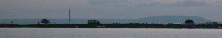
071107 07:00 At wake up, the island is all around us until the horizon, only at at the side of Homa mountain we see some water far, but again plants behind that water.
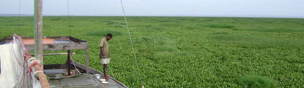
Photo: Plants (mainly water hyacinth with reed ) to the horizon, that is, at least 5 km to all sides. Our surprise island is AT LEAST PI * 52 = 78 km2.
What can we do? A floating island moves with the wind. If you
are anchored, you move with same speed in the opposite direction "over" the
island. You have to choose where you want to reach its "shore". We choose for
flight, that is, we give up Kisumu. Hence, we will be anchored when the island
moves NE, and we will lift anchor and float with the island as long as it
moves SW.
09:00 NNW 2-3, later W to SW. Plants start to move E later NE. We put our anchor. Again the grazing sound of plants
along our hull.
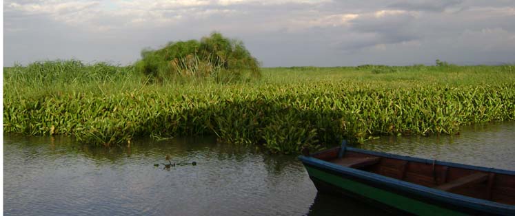
Photo NE: Behind us the plants join again. Foreground water hyacinth, left background reed, then papyrus reaching high
12:00 Still grazing
sounds along hull. Anchor line strained but holds. We anxiously look for "shore"
and water Westward, but sight none yet. Then, the movement of grass stops. No
more grazing sounds. We switch on GPS. We move 0.6
km/hrs NE. Anchor drag! With great effort, our canoe is moved forward for plant
cutting along the anchor line and bow.
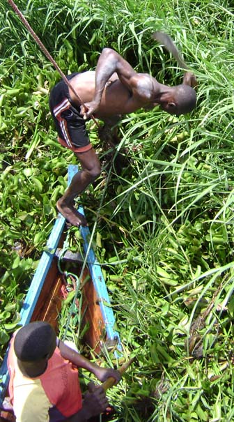
Photo: resolving our first anchor drag
12:30 Drag stops.
13:00 W4. GPS speed still 0.0. I clock the speed of plant movement from bow to
stern (18 m) to be 1 min, which is roughly 1 km/hrs. How many kilometers are
there to go? We still sight no water in our "direction" (if you can speak of
that when you are staying on one place).
14:00 our second anchor drag. This is serious. Mainly reed, with densely
interwoven roots, you can walk on it. It presses our canoe down. Finally the anchor line breaks, the line starts to
disappear in its "hole" through the moving plants. Doi wants to run after it.
"Doi come quickly, that anchor is lost!"
We drop another
anchor.
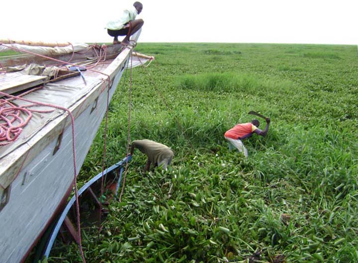
Photo: 14:00 our second anchor drag. Struggling NOT to move with the island. Plants densely pressed, you can walk on them. They press our canoe down. This will end in the breaking of the anchor line and dropping another anchor.
The anchor we now use is our heaviest, and the lines are our strongest. Zero drag, sometimes a little, even though the dhow catches complete sub-islands of densely interwoven plants and drags them along.
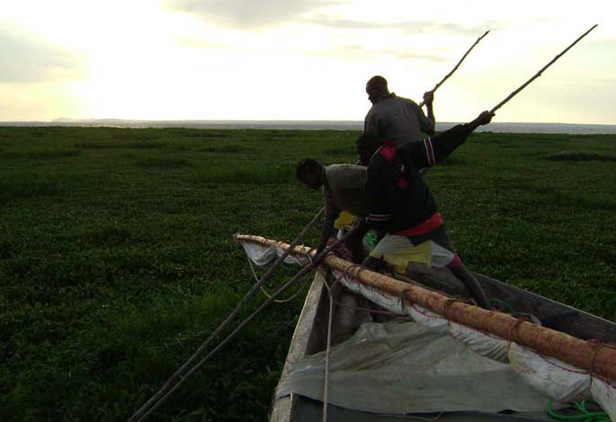
Photo: 18:00, plain water 100 m to go! (point 2 of animation below)
Zero drag! 18:00, after 12 hours we reach the "shore" (or rather, the "shore" reaches us). 12 times 0.8 km/hrs make 10 km, not the 5 we earlier estimated. If we assume we started were somewhere in the middle, the island should be a 20 km by 10 km ellipse (as drawn on map point 6/11), hence 130 or so square km, that is Rusinga and Mfwanganu Island together (or: 3/4 of Buvuma Island, or 1/4 of Ukurewe, or the entire Dutch island of Texel, or 4 times Jersey).
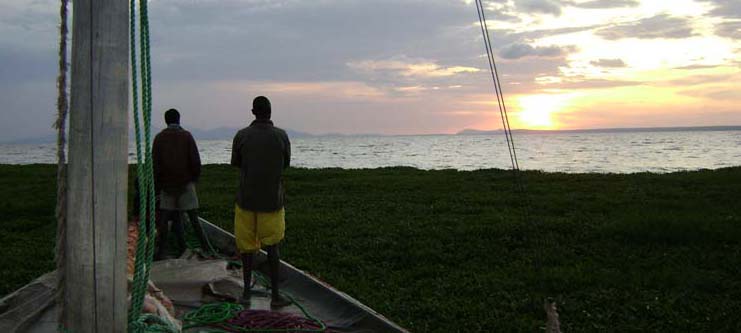
Photo: sunset at the "shore" line (point 2 of animation below)
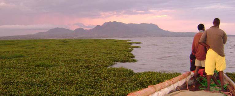
Photo Southward: we actually get out. Homa mountain, rising 560 m above lake level, excellent parasailing. (point 2 of animation below)
Sunset. We are out. We have half an hour of daylight left to search for our
lost anchor (its polyethylene line floats). It should be 300 m NW of us. But we
do not find it. Meanwhile a thunderstorm far SE makes wind E later SE, and the
island comes back! We hasten to lift our anchor but when it gets caught by the
plants, I order to cut it: today's wind had the grace to take us exactly
(!!!) to the "shore" of the island - do not even think of having
stayed 500 m from the "shore" -, we are not going to tempt fate and let us be
absorbed again just in order to save an anchor.
Meanwhile, it is dark. We float inside the last 20 m of the island with the plants WSW 0.6 km/hrs.
Ready to anchor at any wind turn to W. I am writing this story, Philemon lies on
his bed, mourning the loss of two anchors. It does not help to tell him we are lucky. This could have got a
lot worse. And we gained one anchor by not having to pay one white man's visa
for Kenya ($50). And the helicopter dropping food would have cost at least 20
anchors.
"These were very good anchors", Philemon says, gazing to the ceiling.

4 Picture Animation:
Arrival at position 1 at W side of 130 km2 plant island.
First Night: the island floats 10 km SW absorbing us
Next day (on anchor): slight anchor drag NE to position 2, island moves 10 km back NE, we just
reach the "shore". We loose one anchor.
Second Night: island moves SW again, anchor refuses to come up, we cut,
hence loose second anchor and drift 20 m "inside" the island to position 3
where we get loose and sail SW.
071108 During the night the wind stays NE 2-3 and we float SW with the island until, at 04:00, point 3 of animation above, Philemon reports to be free of plants. We lift sail at 04:15 and almost reach Rusinga before the afternoon W sets in at 11:30 (see map point 8/11). In the shore village, we do our first shopping since Musoma, find fish, bread (!), chapatti, sugar, and even buy meat.
Photo: map point 8/11. In the shore village, we do our first shopping since Musoma, find fish, bread (!), chapatti, sugar, and even buy meat. Note crew, on own initiative, sticks to "Saa Moja" cap dress code when going on land.